The Great COVID Panic of 2020 led to the cancellation of in person cycling events around the world. Among the gravel rides the most notable cancellation was Dirty Kanza, a 200 mile gravel race in the Flint Hills of Kansas. As things started to open up for people to go outside, a former pro from the European peloton organized a DIY event he named Dirty Kanzelled. The idea for the event was for participants to design their own self-supported route near their homes and ride alone or with a handful of friends. Wanting to get out and about, I decided to join in. My conditioning was pretty good as I had continued riding all through the lockdown, and the riding was actually pretty nice as the roads were traffic-free. Making lemonade out of lemons.
Designing my own route had a couple challenges. First, 200 miles is a ride too far for me. Every time I’ve done 100 miles I’ve asked myself, “Do you want to do another 100 right now?” and the answer has always been “Are you effing kidding?” Maybe it’s a mental thing. Maybe if I set out knowing the ride was going to be 200 miles I could do it, but it definitely sounds like Type 2 Fun at best, and probably even Type 3 Fun. Fortunately Dirty Kanzelled had a 100 mile option which was just right for me.

Another challenge is finding suitable gravel roads to ride. Most of the gravel roads around here are fire roads in the hills that have extremely steep pitches which would quickly wear me out and involve a lot of walking. Most of the non-brutal gravel roads I can see on satellite maps are on private land which is a no go.
The last problem was finding places to refill on food and water. Many drinking fountains in parks were shut off due to the panic and “The Science”, and food options were likely to be limited to what I could find at a gas station.
After much research I devised a route that strung together trails in regional parks with a handful of gravel paths in between, but mostly I would be on asphalt. As for food and drink, I had enough on-bike storage for food, but I was going to have to be flexible in my quest for water and change my route on the fly if necessary.
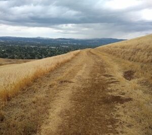
I set out at the break of dawn. Like Pearl Harbor there was a little nip in the air. I was underdressed for the current temperature, but I figured it would warm up so I left the extra layers behind. I headed over the hills and past the Altamont Speedway, home of the famous Rolling Stones concert, and onto the first gravel section along the California Aqueduct, which carries water to Los Angeles so Angelenos can water their sidewalks.
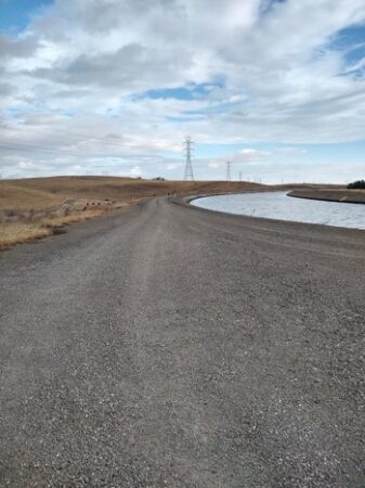
California Aqueduct
The first section gravel ended, and I dropped further down the hill and into the San Joaquin Valley. After a few tense miles on a two lane road with fast traffic and no shoulder, I turned west back into the hills. As it was still early the traffic was not as bad as it could have been. Heading through a small town it started to rain. This was an unpleasant surprise. The cloud cover was welcome as it would keep it from getting too hot later in the day, but I was unprepared for rain. I checked my weather app, and it looked like this was an isolated shower that would soon pass, so I waited about 15 minutes under a tree before setting off again.
30 miles and about two hours in I came to what I had hoped would be my first water stop at Round Valley Regional Park, but no, the water fountains had been shut off. Stupid, stupid bastards. My route had an option for some gravel roads here, but I decided to bypass this section in order to preserve my water. The road continued through rolling hills and ranches until I reached Empire Mine Road, which is closed off to cars making it quite pleasant. About a mile down the road I passed the Gates of Hell, which is supposed to be haunted, but which doesn’t look too ominous in daylight. A little further was a turnoff on the Starmine Trail, but the gate was locked and had a no trespassing sign even though the trail was in a public park. Being California just because something is called a public park doesn’t mean the public gets to use it. This was another spot where I thought I could add some gravel, but not knowing the trail and wanting to conserve my water, I took the locked gate as a sign to stay on the paved road. In hindsight I should have hopped the fence.
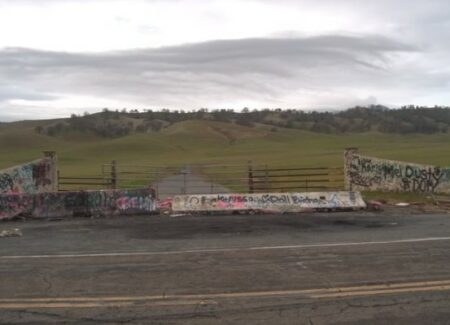
Gates of Hell
At about mile 40 I reached the parking lot for the Black Diamond Mines Regional Preserve. Now I could get back onto some gravel. These were roads I had hiked before. This area used to be the site of coal mines from the second half of the 19th century. In the first half of the 20th century they mined sand used for glassmaking and steel casting. There were five supporting townsites in the area, but today little trace remains as the miners took the wood for their homes with them when they left. Good wood must have been a valuable commodity. (That’s what she said.) The mines are closed off lest someone wants to play Tom Sawyer, but that didn’t stop some kids from getting killed by methane gas back in the 80s. The old cemetery is fascinating due to the young age of so many of those buried there. Infant mortality was seriously high in those days.
Black Diamond
I rode as far as a prospect tunnel (not to be confused with a bonus hole) for a submission to the “Photos of Bikes Leaning on Stuff” genre. There’s a lot to explore in this park, but water was running low, so I decided to head out to the picnic area hoping to find a working fountain. When I got there the fountain was covered in a plastic sheet. Stupid, stupid bastards. But wait, I peeled back the sheet and lo and behold the fountain was working. It felt like victory. Time for a break to drink some water and eat some food.
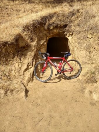
Bike leaning on stuff.
Bottles and belly refilled, I turned west along a bike path until I reached the road over some hills. There were three possible routes over the hills. Two of them were four lane roads with fast traffic and a small shoulder. Third was a narrow, twistier road with no shoulder. I picked the third route figuring it would have less and slower traffic. I was probably right about the traffic, but it was still a few miles of butt clenching as cars whizzed past. I could have shoved some of that coal from the Black Diamond Mines up my ass and turned it into a diamond by the top of the hill. After about 15 minutes of climbing I made it to the summit and coasted down toward the defunct Concord Naval Weapons station and a wider road.
Now I was into a maze of suburban neighborhoods. As I didn’t have a bike computer I had to navigate using the phone in my pocket, which meant a lot of getting lost and stopping to look at my phone. Eventually I found my route to the top of Lime Ridge which was narrow, steep and bouncy, so I had to get off and walk a bit. A pain in the neck, but this too is part of gravel riding. After a steep descent off the ridge I was back onto a bike trail next to a canal heading toward my next planned pit stop at about mile 60. Surprise, surprise, at this stop the fountain was uncovered and the water was flowing. Time to fill up the bottles and eat some of my wife’s homemade bread for carbs.
Lime Ridge
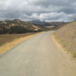
The route turned south for the push for home, but one more obstacle remained, Shell Ridge. The ridge gets its name from the shells that are fossilized in the sandstone, indicating that this used to be the seafloor. The ridge was formerly ranchland but now is a park with numerous trails winding through the oaks. My route bailed out on the dirt after a couple miles as I was unfamiliar with the area when designing the route. If I was more familiar with the trails I could have continued on for a couple more miles of nice dirt road. Live and learn.
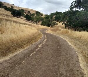
Shell Ridge
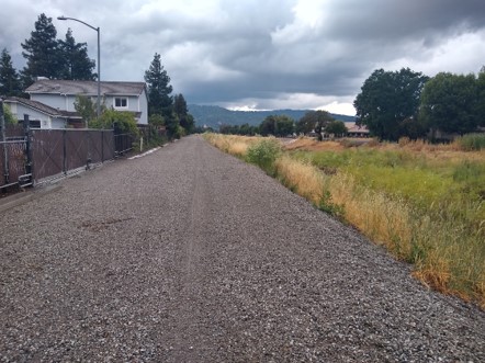
Back onto asphalt I descended the hill to the Iron Horse Trail, which as the name implies is on an old railroad grade, which in turn means that it is going to be flat. The trail is really pretty boring as it goes straight through suburbia, but at mile 80 a surprise thunderstorm spiced things up. I took shelter under an umbrella supported by a big metal pole. Tell me you have little experience with thunderstorms without telling me you have little experience with thunderstorms. I was soon joined by a pair of cyclists, which somehow made me feel less stupid for standing by a lightning rod as if there’s a finite amount of stupidity and it was now shared by three people. I know I should have moved to a different spot, but man, it was pissing down rain, and there was a chance that the lady cyclist would end up with a wet t-shirt, so I stayed put.
The storm passed and I set off again for the final 20 miles. The previously languid canals by the trail now were turgid with muddy water. Before long I was back onto gravel which now was sticking to my tires due to the wet making the wheels heavy and harder to pedal. That’s ok though, I had the wind at my back and in the distance I could see the hills by my house. The end was in sight. Another shower must have just passed as I rolled into my hometown as water was running in the road. It had been dry all winter and today it decided to rain. SMH. I made a gametime decision to modify the route to avoid a potentially muddy section and instead to go through the downtown area. As I neared home, I hopped off my bike to cross a normally dry creek and back onto some gravel for the last few hundred yards of the ride.
The end is near.
All said and done it was about 103 miles in 8 hours with about 4200 feet of climbing. It felt good to get out and about after being locked down for months. It also felt good to do the ride completely self-supported. Will I ever do the real Dirty Kanza? Probably not. For one thing it’s not called that anymore, because the name was offensive to the Kanza tribe. (I’m not a fan of the woke, but I kind of understand this one.) Even so, I also doubt I will ever do its successor event, lamely named Unbound. It’s a long way to travel in order to suffer. Even if I do participate, I doubt it will be the 200 miler. 100 is about right. Nevertheless, it was certainly not my last gravel ride. I now had the bug.
The internet hates bicycles, apparently.
We’re just blocking the tubes like we block traffic.
Every time I’ve done 100 miles I’ve asked myself, “Do you want to do another 100 right now?” and the answer has always been “Are you effing kidding?” Maybe it’s a mental thing. Maybe if I set out knowing the ride was going to be 200 miles I could do it
Easy. Just have your wife dump you off someplace 200 miles away, and say, “See you at home, dear.”
Just to remind people, AAA supports bikes in most locations as well (as long as the bike will fit on a standard rack, so you’re out of luck recumbent freaks).
“My bike is out of gas… No, I’m not on a motorcycle, a bicycle… No, this is not a prank call… Hello? Hello?”
Maybe you need a charge for your ebike?
🤔 💫
While you’re waiting for AAA, you can collect some firewood, start a fire, build a lean-to, and gather some brush to sleep on so you’re well rested when they finally show up.
😮
That could actually be handy.
Yep. I just learned it in the past year, so I’ve taken to carrying a AAA card in my cycling kit just in case.
2 miles sounds pleasant. ¯\_(ツ)_/¯
On a nice, flat asphalt path without much grade 10 miles doesn’t feel like much at all. 100 is a lot, I think, and 200 sounds like a dumb idea.
I once did about 30 miles, drunk, on a cruddy bike and with a heavy pack. That was enough fun for me. Passed out in the forest and woke up to a deer trying to eat me.
If she thought she could get away with it, she’d drop me off 500 miles away.
You forgot Fun Type 4 – Not Fun to do; Not Fun in Retrospect; Makes a terrible story.
I’ve had too much type 4 fun.
This one time? In Tijuana? …
Thankfully not.
Type 5: No fun to do, no retrospect nor story because you didn’t live to think nor tell about it.
A story that starts off with “This is no shit”?
I thought it was supposed to be “No shit, there I was…”
The Flint Hills of Kansas are gorgeous in the summer. Stacked stone fences line the twisty river roads, huge tracts of waving prairie grass. I’ve had many pleasant motorcycle rides through there. I can’t imagine riding a bicycle in the Kansas heat though.
That is pretty country.
I love the Fun Scale! And a little nip in the air 😉
I don’t think I’ve ever ridden more than about 20 miles. But I dig reading about your distance adventures!
*waves giant Toblerone*
Happy Swiss Independence Day!
*Scowls in Holy Roman Emperor*
/cuddles Schmidt-Rubin collection
Are you sure the one in the middle isn’t actually a man? And maybe the second from the left? How about the one to the left of center?
Damn Swiss, do better.
Reminds me of the line, if you see an attractive woman in Vienna, she must be a foreigner. Apparently it’s similar in Switzerland.
“Like Pearl Harbor there was a little nip in the air.”
Guffaw
“the California Aqueduct, which carries water to Los Angeles so Angelenos can water their sidewalks.”
Another good one.
“In hindsight I should have hopped the fence.”
Yup. I hopped many barriers during COVID, showing my son not to follow stupid tyrants. Dunno if he remembers any of it.
I like the pictures. I also like the little side-trips like the history of the mining towns.
The site is not behaving well today.
Storyteller-in-Chief
“Being able to tell a story about the economy is important,” said Angela Hanks, chief of programs at Demos, a progressive think tank, and a former official at the Department of Labor. “It doesn’t have to be a book about the economy, but it has to be a story that people can understand and hold in their heads and connect to things that are happening in their real lives.”
——-
Bidenomics is a made-up way to package some very real things. Legislatively, it entails items such as the American Rescue Plan, the Inflation Reduction Act, the bipartisan infrastructure bill, and the CHIPS Act. On the regulatory front, it tries to boost competition in ways big, such as antitrust enforcement, and small, like eliminating junk fees. From the bully pulpit, it is a bent that is more pro-worker and focused on specific industries.
The way the White House lays it out, at the core of Bidenomics are three pillars: making smart public investments in America, empowering and educating workers, and promoting competition. Within those pillars, Bidenomics takes big swings at change but also tackles issues at the margins, and some of it appears to be working.
“It’s a very sweeping economic agenda,” said Jared Bernstein, chair of the White House Council of Economic Advisers. “Remember, there are a lot of ways to build the economy from the middle out and the bottom up, everything from setting up a factory that wasn’t there before, frankly, standing up an industry that wasn’t there before, to making your experience at StubHub and or renting an apartment more hassle-free and less expensive. It’s very micro, and it’s very macro.”
Or you could just call it what it is: fascist industrial policy.
Or you could call it “Bullshit”, shorter and more accurate.
Tell a story
Spin a line of bullshit, you mean.
He doesn’t need to convince anybody. I’ve already started to see stories on the “news” about how “Akshually the economy is great!”
“Who ya gonna believe, us or your lying eyes?”
making your experience at StubHub and or renting an apartment more hassle-free and less expensive
Everyone knows the government specializes in making things hassle-free and less expensive.
As anyone who has ever been to a DMV knows.
Emily Stewart
Columbia University
Bachelor of Arts, Comparative Literature & Society
Activities and societies: Sigma Delta Tau, Columbia University Women’s Rowing
Graduated with Honors
Roughly 13 years of various work experiences. So perfectly qualified to speak on Economics.
Oh HELL no.
Bidenomics is articulating an approach for progressive supply-side economics, which Treasury Secretary Janet Yellen has made the case for in the past. Running in contrast with the Reaganomics view of supply-side economics, meaning tax cuts and deregulation to incentivize growth, this modern progressive view seeks to increase labor supply and invest in infrastructure. It also entails the federal government putting its thumb on the scale in favor of issues such as climate and technology.
“This is the left’s supply-side argument,” Hanks said. “What does it look like to have a supply-side policy where you invest in building things and doing things and pay attention to whether you’re creating the conditions for people who have been left out to get a job? It feels, frankly, like something that in the past folks have been hesitant to try.”
We’ll do these things and build these things whether anybody really wants them or not.
Never been tried before, lol. We tried it before, it was called the “New Deal”, and it resulted in a decade of misery.
Meet the new New Deal, same as the old New Deal.
Thanks JR, always enjoy a vicarious road trip. I occasionally take a short motorized trip around the neighborhood, remembering those people and places I used to know. A lot of changes, new faces.
Local ray of sunshine. One lucky guy.
https://www.newsday.com/long-island/suffolk/copiague-cedar-beach-swimmer-rescued-current-fy6iei47
Superconductor Breakthrough Replicated, Twice, in Preliminary Testing
So, not actual replication?
Note – I can’t trust the Chinese team’s output.
I don’t believe it
West Africa is getting really spicy.
EU countries are evacuating people from Niger. Sierra Leone just put down a coup.
The President of Burkina Faso issues some threats.
President of Guinea issues threats.
You aren’t gonna believe this, but it all involves western countries and resources!
So, “We’re going to destroy your environment and make your kids work in mines so we can have electric cars and solar panels, and we’re going to prevent you from getting rich using fossil fuels like we did” is not a winning message?
It’s not just the mines.
Europe truly fucked themselves. This is why they will go to war.
Nigeria has a coast, boats may not be as cost effective as a pipeline, but the seas can be easily defended.
Boo fucking hoo. Poor Europe is losing a major grift.
What camo pattern is that on the top link?
Dude has two (2!) radios, such a boss. Not to be trifled with.
I can only hope that he has a gold Desert Eagle on his side.
Guess what? All of those countries except Niger have signed on to “Belt & Road” – i.e. to be colonies of China.
This is fucked up.
Europe is getting more absurd every day.
All they need to to is show up at the US southern border.
And maybe bring some sun screen.
Know the site is on the fritz so this might end up in a ded thread or eaten by the server elder gods.
So a guy from where I am going to work reached out to me today. A peer. Apparently he was the guy I beat out for the job. “It was my turn” “I have been staring at that job for 18 years!” etc. Thinking I better reach out to new manager about that.
Damn. Start calling him “Hillary”. That should smooth things over.
“Be better.”
Is the guy known to be a loon?
I can’t imagine ever making that complaint. Especially not to the guy who just got it. 😂
That’s stalker level shit.
Right? Did he expect OBE to turn it down and ask them to give it to someone “more deserving”? I don’t think it works that way.
Seriously. That is not normal.
Sic him on the hiring panel. Or figure out who the shitty boss is and blame him.
Well, I have a post going up at 7 pm CDT. If the site is working, I will be hanging around. If not, I might not be there to see your comments.
Lunch cave man style today. Winco deli sells fried chicken by the piece. I just gobbled down three thighs, while standing over the kitchen sink. Not pretty, but mighty tasty.
And speaking of thighs… there was this girl at the store. When I first caught sight of her, from astern, I figured she was probably a college volleyball player. When I saw her from the front (not that I was stalking her or anything creepy) she definitely looked a bit older- thirties maybe. Anyway. She must have been six-one-or-two. Long lean strong legs, lovely round muscular bottom. A girl who could leap tall buildings at a single bound. Yabba dabba doo.
The ‘Barbie’ Movie Is Ending Relationships Left And Right
On TikTok, another woman said the Mattel movie inspired her to break up with her boyfriend after a string of bad behavior on his part: “Thank you, ‘Barbie’ for empowering me, for giving me the confidence, for making me realize I deserve better.”
Meanwhile the boyfriend says “Thank you, Barbie, for helping me dodge that bullet.”
*sigh*
In unrelated news, guys left and right are high-fiving each other. “Dude, dodged that bullet!” “Right, bruh?!”
Can’t afford an EV? Just pay people more!
https://prospect.org/economy/2023-07-31-ford-electric-cars-arent-affordable/
Ford can raise wages, then require employees to buy EVs, that are financed through Ford.
“I owe my soul to the company store”
In 1914, founding father Henry Ford created the assembly line and thereby invented mass production of a costly product. Soon thereafter, he did something equally revolutionary: He raised the wages of his assembly-line workers to $5 a day—by the standards of the time, a huge leap in income for unskilled or semi-skilled production workers.
More importantly than the wages? He hugely decreased the cost of an automobile; which this a-hole just ignores.
“Thank you, ‘Barbie’ for empowering me, for giving me the confidence, for making me realize I deserve better.”
People who organize their lives based on what they see in the movies might be on shaky ground, mentally.
I take issue with that statement; we learn by observing and by learning from others. Humans learn from stories – for example, I base my life on ‘Conan – The Barbarian’, but that’s neither here nor there – and movies are a modern exposition of human experience that we use to guide our own lives. It doesn’t imply mental shakiness. Now, in the particular, if you are basing your life (or learning lessons) from stories and ideas as corrupt and malevolent as ‘Barbie’, you’re not going to end up in a good place, but that doesn’t negate the reality that these stories are how we learn to live and exist, just that you should be careful in what stories you choose.
What is good? To see your Kens driven before you and to hear the lamentation of their Barbies.
Okay, you people have your evening links. We know the website is wonky.
Just pay people more!
Sounds legit.
Raise costs. Lower prices. Everybody wins!
More importantly than the wages? He hugely decreased the cost of an automobile; which this a-hole just ignores.
Just think how much the guys at Duesenberg could have been making.