Since its inception I have ridden the local annual century ride for Habitrail for Humanity, but in 2020 as we were still dealing with the lockdowns, the event became a DIY affair with riders designing their own routes and riding on their own. This gave me an excuse to do a ride I had long wanted to do on some little traveled roads to the south. My route was essentially a trapezoid: east to the San Joaquin Valley, south along the California Aqueduct, west into the mountains, and north back home.
The start of the ride was uneventful as I rode east to the big valley and got on the trail next to the California Aqueduct heading south. Before long I hit a locked gate across the trail. There used to be an opening that allowed people to go through, but that was gone. I took a chance that the trail would still be open past the gate and climbed through the barbed wire fence on the side, which reminded me that I needed a tetanus shot. At one point the trail dead ended as it passed under a freeway so I had to backtrack a little to get onto some farm roads, an unexpected but minor inconvenience which added a couple miles by the time I got back onto the aqueduct trail.
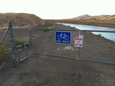
Aqueduct Trail
About mile 35 I noticed a pair of sporty black cars pull up through the orchard at the base of the aqueduct about 40-50 feet below where I was riding. Out climbed some young hombres carrying pistols. One of them might have been named Palomitas de Maiz. Hopefully they were just there to have some fun shooting cans or something, but I didn’t want to stick around to find out. If I happened to be at the wrong place at the wrong time it would have been easy to push my body into the water to dispose of any witnesses. Even though I’m pretty sure they saw me when they pulled up, I edged closer to the water side of the trail where I’d be less visible and pushed the pedals a little harder to put some distance between us. When I figured I was out of range I breathed a sigh of relief and slowed my pace. I suppose if push came to shove I could have fended him off with a rusty bike chain.
At mile 45 I pulled into the town of Patterson for my first rest stop. Nearly halfway. So far it had been easy, and it had only taken me about 3 hours. But to this point it was flat with little wind. I had a nature break at the gas station, filled up my water bottles and grabbed a coffee. I didn’t linger long as I had a 2900 foot climb over the next 20 miles, and I wanted to get going before heat and headwinds had a chance to kick in. Back on the road I turned west to head into the mountains on del Puerto Canyon Road. Before long I was into the blackened hillsides that had burned during the big fires in 2020, the same fires that turned the sky black in the Bay Area. The first part of the road is along an old railroad grade, so just a gradual uphill as it winds up the canyon. About 2/3 of the way up the road, close to the end of the easy part, there’s a mysterious hole in the rock covered by steel doors. Inside is just a room so it’s not part of any mine. I assume it’s somehow related to the old railroad but I haven’t been able to find details.
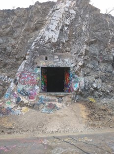
Mysterious Bonus Hole
The railroad supported the magnesite mines that operated in the mountains in the first half of the 20th century. Magnesite is used as a refractory material and in flooring and they even attempted to make decorative products like window sills and fireplace mantles from it due to its bright white color. There were two ways to bring the material down off the mountain, either by rail to the east or by road to the north. The rail line to the east was more reliable, but a much longer distance to market. An aerial tramway brought the magnesite off the mountain to the rail head, the trains took it out to the San Joaquin Valley before going north then west to the Bay Area. The road to the north of the mines was more direct, but could be a muddy mess in the winter as the heavy trucks chewed up the dirt road.
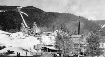
Magnesite Mine
A little further up the road where it starts to get steep is Adobe Springs, which advertises itself as high magnesium, high health water. Unbeknownst to me at the time there’s a public tap where people can fill up their bottles. I wish I had known at the time, because I could have used the electrolytes. They’re what legs crave during a long climb. As it was, I bypassed the springs and started the steep part of the climb, about 1.5 miles at 10% with pitches up to 16%. I could feel my legs on the verge of cramping so I took a couple breaks on the way to the top.
Over the top and into the San Antonio Valley signs of human habitation reappeared. Widely dispersed homes were still standing in the midst of the burnt landscape. The firemen did a pretty remarkable job saving as many structures as they did. A couple miles of coasting brought me to my lunch break at The Junction, a restaurant in the middle of nowhere popular with the local ranchers, cyclists, classic car enthusiasts, and bikers.
As it was The Junction’s last day, it was pretty crowded. Between the remote location, the fires, and the lockdown, they couldn’t stay in business. The management at The Junction changes hands pretty frequently. When the old management calls it quits, someone else decides to give it a go. The quality of the food varies wildly depending on who is running the place, ranging from great to horrible, so check the most recent reviews before you go. This year’s rains washed out the road and once again there’s new management, maybe the third since the pandemic. The only one that seems to make out on the deal is the guy who owns the building.
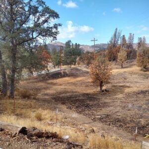
Fire Damage up to Edge of Parking Lot
The Junction is so named because it stands at the junction of three roads. To the east is the road I just climbed out of the San Joaquin Valley. To the south is Shanti Ashrama, a Hindu retreat built not for the Indians in Silicon Valley, but for American ”spiritual but not religious” types who were followers of Swami Vivekananda over 100 years ago. Further up the road on top of Mt. Hamilton is the Lick Observatory. No, that’s not a porn studio. This isn’t the San Fernando Valley. However, it does have large telescopes pointed at Uranus. Eventually that road ends in San Jose. To the north is Mines Road, which was the more direct route to take material out of the mines, and also was my route to take me to the end of the ride.
The roads north and south roughly follow the old Mexican road, La Vereda del Monte. If you’ve driven Highway 101 you are probably familiar with El Camino Real, which connected most of the missions in California during Spanish times. If you’ve driven I-5, probably without realizing it you’ve roughly traced the path of El Camino Viejo, which was a shorter but hotter and dryer route between LA and the Bay Area. La Vereda was the route between El Camino Real to the west and El Camino Viejo to the east through the rugged mountains. It was the route to take if you didn’t want to be noticed and was popular with horse thieves like Joaquin Murrieta on their way to Sonora in Mexico. The names in the area attest to its wild history: Hideout Canyon, Horsethief Canyon and Murderer’s Gulch.
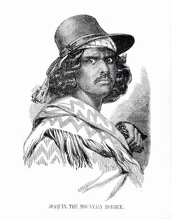
Joaquin Murrieta’s head before it went into a jar.
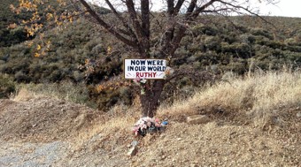
Fortunately the horse thieves and bandits are long gone, and while there have been bike-jackings in other parts of the Bay Area, there have been none here. I stopped at the Cal Fire station to fill up my water bottles. Most fire stations typically will have publicly available water, at least in California. There were two last substantial climbs, about 1000 feet in total, before a long downhill run toward home. Evidence of the fire was still everywhere: charred landscape, a handful of burned structures, and also the disappearance of a cryptic sign at the top of the hill that had read, “Now we’re in our world Ruthy”. I’m not sure if that sign was a memorial to some Ruthy, if it was some kind of welcome to the people coming out to the sticks, because it really is a different world from the metropolis just a dozen miles away as the crow flies, or if it was an advertisement for Ruthy’s Trash and Treasure, which is mostly a bunch of trash in someone’s front yard down the road.
What does it all mean?
At the bottom of the long 18 mile descent I stopped to take a leak and to check my phone to make sure I was closing in on 100 miles as planned. Oh crap, the battery was at about 5%, probably due to being without a signal for so long, which seems to drain the battery. Forget about checking mileage, I just need to get home to charge the battery. If the battery dies, I might lose the record of the ride and it will be like it never happened. Luckily I made it home in time to save the ride.
According to Strava I did 188 km or 117 miles. At first I felt pretty proud of myself. It was a new personal record. Then I thought, well shoot, I was feeling pretty good. I should have just gone the extra 12 km to make an even 200. Then I noticed the trace on the map looked all screwed up. The low battery must have caused a problem with the tracking. I did a manual calculation and it came out to a little over 172 km or 107 miles. I had still achieved my goal and it was still a personal record, but now my Strava record was a lie, a lie out there for all to see. I was going to have to remedy this. I was going to have to ride 200 km to clear my conscience. But that’s for another day.
so leather and Lycra with a little 5W-30 to grease the gears
/not kink shaming
Shh. What happens at The Junction stays at The Junction.
This is one of those WEF sustainable housing plans?
https://www.theonion.com/habitrail-for-humanity-under-fire-1819567883
When I went to Joe Biden’s alma mater there was a pedestrian overpass that we all avoided. It required lots of steps and got ridiculously hot whenever the sun was shining even in winter.
We all called it “the habitrail”.
https://www.newarkpostonline.com/news/out-of-the-attic-south-college-avenue-pedestrian-walkway-1992/article_74f01179-b27e-54e6-99ba-c67edc9f6706.html
It’s since been replaced.
https://www.flickr.com/photos/cogdog/2554454685
Sounds fun. I’d love to do a ride like that…on an e-bike.
I was thinking dirt bike, but yeah.
Shouldn’t that be Maiz de Palomitas ?
Also the story of Joaquin Murrieta looks interesting, too bad the head is destroyed.
Did you have any issues with the Strava data being screwy from the event organizers?
Really enjoyed the story, but I still think you’re crazy.
“Shouldn’t that be Maiz de Palomitas?” I’m just going with Google’s translation of Corn Pop.
“Did you have any issues with the Strava data being screwy from the event organizers?” No, the organizers didn’t have anything to do with it. I designed the route myself. I think the problem is that the phone battery gets drained when I’m in an area without coverage. Compounding that, I had the Strava beacon on so my wife could find my body if necessary, and that probably drained the battery too. Once the battery got too low, I assume the GPS measurements went haywire. There have been times when I’ve downloaded a map to Strava from Ride with GPS, and the map has come out screwy, but that’s because Ride with GPS allows you to download two types of gpx files and I chose the wrong one.
Adobe Springs: Only $400 a year subscription fee to enter and use the facilities. If you need to make a recurring form, you’ll need the additional Adobe Falls package for $250 extra per year!
Speaking of fire damage…
The AP is now reporting that people died because the roads out of town were blockaded. Those who drove around them or ran away lived. The rest were burned to death in their cars.
https://apnews.com/article/hawaii-fires-timeline-maui-lahaina-road-block-c8522222f6de587bd14b2da0020c40e9
Well it’s about time they started reporting on it. There have been videos of the blockades taken by some who managed to survive (in the first video below they went to the beach and into the water) and eyewitnesses who saw the cars being blocked and the fires catching up to them.
Chaotic Maui Evacuation: Police Block Exits As Wildfire Forces Ocean Escape
Maui Police Blocked Escape Routed as told by FISH from Front Street Found ALIVE!
One wonders if they started reporting on it to take the heat off of Biden and put it on the local authorities.
A rare case where the blame is being put where it should be put.
I bet you’re right.
This is reminiscent of Atlas Shrugged. We have a huge lack of good leadership in our country. Everyone is too worried about DIE, climate change, and “getting” Trump to actually do their job. And now people are dying because of this incompetence.
BUT WE’RE MORE DIVERSE AND THAT’S SAVING
LIVESFEELINGSThe Italians criminally charging a bunch of scientists because they failed to predict an earthquake was crazy. This is entirely different and there are at least a few people that deserve to hang for this.
The guy who didn’t turn on the water is already in hiding. I think this is gonna get really dark.
Forgive me, but I hope it does. These need to be consequences. Preferrably fatal.
Used to be enforced from above, but that’s not likely to pass, so enforcement from below will replace it.
“enforcement from below“
Our ruling class either doesn’t believe such a thing exists at all, or that it can’t happen to them.
I, for one, am surprised none of the Uvalde cops have been, err, rectified.
That surprises me too. My wife is a pretty non political normie, but when she saw the cops keep the parents from entering the school while not trying to stop the shooter, she went full Me on the cops. I cant believe there aren’t a bunch of citizens of uvalde who feel that way times 10.
What was that line? ‘The course of action I suggest, is the course of action I can’t suggest…’
I’m thinking that things need to get really dark all over North America, and possibly most of the Western world, so that our Moral And Intellectual Betters™ will finally understand that they are our employees and not rock stars.
So, government officials did not use warning sirens, withheld water, and blockaded the road out. It makes you wonder what they would have done differently if they were trying to kill as many people as possible.
They would have banned gay porn from kindergarten libraries.
Duh….
But that would only kill LGBTQWERTY people.
“No one else matters!”/non-binary prog
That’s everybody now.
It’s a spectrum!
Let’s see, don’t warn anyone, don’t let anyone put the fire out, don’t let anyone escape.
That about covers it, except for starting the fire in the first place.
Confident prediction: Nobody will even lose their pension.
This is a step or two above normal governmental criminality. wood chippers are called for
Sounds like a nice relaxing (long) ride. Good therapy.
America, fuck yeah!
Mayorkas said DHS is looking into ways of tracking which states and communities implement the administration’s recommended guidelines. He acknowledged guidelines aren’t enforceable, but said they still have teeth.
“They are indeed a set of guidelines. But there are a few tools that we have to drive behavior,” he explained. “One is we have a grant program that distributes much needed funds to communities to enable them to build a greater level of resilience to extreme heat. That’s a matter of incentivizing communities to really participate in what should be a compulsory effort, given the threat to life and to critical infrastructure.”
Land of the free, they said.
Home of the brave, they said.
If that isn’t the poster child for mission creep. DHS was supposed to stop foreign terrorists from blowing up nuclear power plants. Now they’re forcing US citizens to turn down their air conditioning.
Like fucking CISA that went from tracking IT infrastructure vulnerabilities to tracking online “disinformation.”
DHS was always going to be the dept of Internal Security and Citizen Control.
Land of the free
Home of the slave
The code is more like guidelines than actual rules.
given the threat to life and to critical infrastructure.
Stop the invasion. Send the invaders home.
https://www.zerohedge.com/geopolitical/xi-putin-hail-first-brics-expansion-over-decade-two-gulf-oil-powers-join
Arabia and the United Arab to join BRICS in January.
Argentina, Egypt, Ethiopia and Iran will be added to the fold next year.
The Argentina one is interesting since Milei is campaigning on ending their central bank and tying Argentina to the dollar.
You can’t do both. Seems they may be putting the kibosh on his efforts before he even begins.
And Egypt owes money to the IMF. If they default, it’s gonna get spicy.
The AP is now reporting that people died because the roads out of town were blockaded.
Not helpful.
We need to focus our attention on vilifying Exxon and Shell and BP.
Hey now.
Thanks, JR! Another entertaining and informative travelogue.
Regarding the phone: have you considered a solar charger? They aren’t heavy and work pretty well.
Another thing on my list of gadgets to look into. Which one do you have?
It’s not this exact one, but the same brand.
https://www.amazon.com/20000mAh-Portable-Waterproof-Flashlight-Electronic/dp/B08XYY6GDT/ref=sr_1_5?crid=L8AOA61C6MM1&keywords=solar%2Bcharger%2Bfor%2Bcell%2Bphone&qid=1692898930&sprefix=solar%2Bcharger%2Caps%2C170&sr=8-5&th=1
Looks nearly exactly the same as the one that I’ve got. It’s a bit hefty for a ride though, if I’m doing a long ride, I’ll through in a much smaller (and lighter) battery pack.
Don’t you guys hang shit off your bike anyway? Bags, etc?
I clip it to my pack and don’t even notice it.
Depends on the bike. My road bike has two water bottle mounts, a tiny saddlebag, lights, and a bike computer. My hybrid (which I usually use for longer rides due to the road conditions in some of the areas) has two water bottle mounts, tiny saddlebag, lights, rear shelf, and detachable panniers (that clip onto the rear shelf), and a small snack bag on the handlebar.
I’m very far from a weight weenie, but the solar battery weighs about a pound more, and is too large to fit into the small saddlebag or the jersey pocket. The small one will, and still can generally charge my phone twice.
I’ve brought battery packs before, but when tight on space in my pockets and bike bags, it’s one of the first things that I leave behind.
Ad firm behind Bud Light’s Dylan Mulvaney fiasco fires 13 staffers after lavish French trip: sources
The California marketing firm behind Bud Light’s disastrous tie-up with Dylan Mulvaney fired more than a dozen employees — days after top brass boasted about a lavish junket to an award ceremony on the French Riviera, The Post has learned.
San Mateo-based Captiv8 — which The Post exclusively identified as the ad agency behind Anheuser-Busch’s short-lived partnership with the trans influencer — flew executives and guests on a private jet to the annual Cannes-Lions festival in June.
Captiv8 booked the private charter on a boutique French airline called La Compagnie, which features 76 lay-flat seats and a “bespoke plane experience,” according to a press release about the trip.
Upon returning from the marketing industry’s Oscars-like event, CEO Krishna Subramanian offered a recap of their trip during a company-wide Zoom meeting on July 3, multiple sources told The Post.
The presentation allegedly included photos of the giddy travelers aboard the luxury jet, as well as the yachts, pool parties and villas they visited in the South of France.
Two days later, however, the “tone-deaf” Subramanian handed out pink slips to 13 workers, about 5% of Captiv8’s more than 200 employees, a Captiv8 employee told The Post.
— insert Drinker’s video clip “yes I definitely smell shiite.” —
Simping for the woke pays well, apparently.
That’s a hell of a catch, that catch-22
https://twitter.com/stillgray/status/1694748105907027969
“Nice little operation you have here, it would be a shame if something happened to it…”
Mobsters without the fashion sense.
Uh, megacorp only hires U.S. citizens and lawful permanent residents. I guess we’re next on the list. Every defense contractor is now on the waiting list to be sued by Justice.
Best there is.
I don’t agree that it’s a political attack. I think it’s always been about getting foreign spies in there. Bribes have been paid to the pols, now they want some results.
Deemed export:
The release of “technology” or “software” to a foreign national in the United States is “deemed” to be an export, even though the release took place within the United States.
So in order to avoid having operations hindered by normal activities that would fall under export control laws they simply didn’t bother to interview any foreign nationals. I guess the only option would be some sort of kabuki interviews where you spend time interviewing people who would be disqualified under export control laws.
As I recall, the staff that empties the waste baskets has to be a US citizen or legal resident. Otherwise, special care must be made to clear all desks, all white boards, and dumping technical data into locked bins.
Correct as well, according to the letter of the law.
Yup. I have an immigrant friend that covered aerospace and defense on Wall St and he had to document that he was just here on work visa, but was a citizen or resident alien.
By that time he was actually a US citizen.
So, to where does Musk pack up and move operations? Mexico?
If I were Musk, I would just move all US government payloads to the back of the line until this goes away. He lifts a lot of weight into orbit for the feds.
That may be a violation of the terms of the contracts.
And here I thought asylees and refugees weren’t allow to work in the US.
Dave Smith’s special is out.
If you listen to Dave a lot, you’ve heard some of the jokes (at least in their infancy), but it’s still funny as hell. His riffing on the 90s is outstanding.
Enjoy!
im gonna listen to that on my home this evening. Libertas was hilarious. His bit on the sign language translator at Mandella’s funeral cracks me up.
There are times when past me was awsome.
I wrapped up my last cleanup of the printer by re-levelling it and getting everything ready to just plug in a new file, pour resin and go. So I was able to just start printing.
I’ll have to remember to pay it forward to future me.
Well, back to trying to get people to read my emails.
Hurry up and wait.
And people Still haven’t responded.
At least I got some other work done.
Stupid Present Me. I was so confident in past me that I didn’t check all of the elements, and the vat wasn’t bolted down!
Well, that print failed spectacularly.
Oops.
Thankfully, the mess was contained. I’ve gotten it cleaned up.
The follow up from the electric motor fiasco this morning.
The manufacturer actually does have a replacement to the part now contrary to what they told me on the email.
It’s four times more expensive, and it’s also on backorder with no estimated ship date.
No wonder they decided to tell people it was discontinued instead.
Bidenomics!
Just wait, I hear inflation is going down so in a few months it should be practically free!
If inflation goes down anymore I should be bankrupt by the end of next year.
Sounds like they don’t actually have it, then.
I went through this with Eaton for over a year trying to get a hydraulic pump to my plant. Every month they pushed the order back another month until i finally cancelled the purchase order and went with a company called fluidyne that makes clones of Eaton/Vickers stuff. They had me three of them in 2 weeks.
My guess is they don’t really have a motor for you. Either send the one that came out of the machine to a rewind shop and have it repaired, or buy a standard NEMA frame and have it modified to fit.
Headed for the first option at this point, if it’s repairable at all.
The second option is a PITA for me, but I’ll do it if I have to. Customer comes first.
Out of curiosity, what’s the data on the motor nameplate. I’m involved in a lot of electric motor, repair, replace, retrofit, activities.
Happy indictment day!
Police with heavy weapons posted up outside the Fulton County Jail. They’re expecting a revolution.
The only “revolution” will be glowing.
I see a lot of mf’s there who need to lay off the donuts.
🤣😂
Kind of an amazing day. The regime going after Trump and Musk and people are fucking cheering. Dummies.
And no uniformed LEO should be allowed to hide their fucking face.
I will make one allowance for the bomb tech actively operating on disarming a bomb.
There’s a mask law in Georgia…
https://law.justia.com/codes/georgia/2022/title-16/chapter-11/article-2/section-16-11-38/
Curious how the most-armed segment of society just keeps… not being violent. Even during an “insurrection”, the most-armed people didn’t shoot anyone. I’m about 100% certain no Trump supporter is going to cause trouble today.
Deep state is going to try harder until they get the provocation they want.
Trump Supporters would do well to not cause trouble. The last group of people who demonstrated for Trump are still in jail.
Are they really cops? Where are their uniforms? And why does the uniformed cop have a mask? Seems kind of totalitarian.
Seems?
Yeah UOD seems whatever you show up in…sorta like the German military
Not heavy weapons, and the dude carrying his pistol on his chest needs to stop LARPing.
Though he might not be able to reach it if it was on his waist.
Ha!
Taser?
I think you’re right.
Dudes in the polo shirts look they’re ready for the pop up target range. Zero reason at this point they should be hold firearms in their hands, nor do they appear to have any actual police gear other than lethal force.
And WTF is up with their suppressed pistol caliber SBRs? Since when is that a standard LEO item?
With the right ammo, you could kill a lot of unarmored people quickly.
I expect an informant will soon brandish a weapon to get the shooting started.
The lunatics are running the asylum.
https://twitter.com/libsoftiktok/status/1694412679421526194
Best response
https://twitter.com/T4YPodcast/status/1694413220063408226
Nice.
On my phone I just saw a guy in a jacket, until I scrolled down and it became a Monty Python sketch.
“Putting the ‘D’ in Democratic Party.”
The banner in the back reads “Fighting Back”. Somebody should call out the Dems for their violent rhetoric.
“Fighting Back” pictured: https://tenor.com/view/weak-slap-gif-18097096
Go Italy!
Once in awhile they get it exactly right!
Those t-bones are cut right.
Milfolini strikes again?
Food is part of their national identity. Good for them.
I don’t even eat boxed or frozen processed garbage if I can avoid it. And they want us to eat something full of mystery chemicals.
And they do it so well. I love all the names they give pasta. Strangle-priests!
It’s the domino theory all over again.
https://twitter.com/EdKrassen/status/1694535808571552146
Ironically the domino theory was in part right. After Viet Nam the commies did take over Laos and Cambodia. Which is where they stopped in SE Asia.
Weren’t those countries already in longstanding civil wars before we left, though? If the domino theory was correct, it should have kept spreading after all three fell to completely to communism.
More than those fell after.
I mean we’re at the “Existing Civil War” phase here now.
The Krassenstein brothers are idiots.
You should listen to the debate between them and Dave Smith/Clint Russell.
I couldn’t take more than about fifteen minutes of it because they were so incredibly dull and ignorant, willfully so.
The Eurozone is there, they can defend themselves. We will bankrupt ourselves trying to hide the world behind our skirts.
Dag nab it. I have been depositing returned child support checks cause Cali can’t cut one check but 18 month worth of checks and previously I had some I was holding onto because Ex was alive. Didn’t see them mixed in until about 10 checks in that are void. Bah stupid me and stupid Cali
Are you her estate executor? Can you cash them?
They are from CA CSS, she never cashed them when alive for nearly two years on our last kid under 18.
That story about SpaceX getting sued by DoJ for only hiring Americans (Nerfherder link) is a perfect jigsaw fit with that New Yorker story about how a lot of people in High Places think Musk has gotten too big for his britches.
It’s four times more expensive, and it’s also on backorder with no estimated ship date.
But when the guy finally gets it. it will save him twelve cents per month on electricity!
Praise Biden.
If you thought they might let you hold them accountable.
https://covidreason.substack.com/p/cdc-now-refusing-new-covid-vaccine
This is going to come to blows.
It seems like the federal government is ramping up the fear mongering for another election-disrupting wave of contagion. Here is a list of ways that presidents over the years have slowly given FEMA the “authority” to enact lockdowns unlike any we have ever seen in this country.
Yikes.
https://www.spartanarmorsystems.com/
Just saying.
I am unfamiliar with such a secretary.
https://en.wikipedia.org/wiki/United_States_Secretary_of_Health_and_Human_Services
They’re all from the early 60’s except for one from 1994. Some are blatantly unconstitutional, were they ever tested in the courts? Or let me guess, nobody had standing because they were never actually used.
I’ve only driven Patterson to San Jose via Mount Hamilton via car, and only once. I think it took 3 hours… it was pretty scenery though, even if my brakes were very unhappy with me. This was before 2020, so I don’t think you were one of the bikers cloggin’ up the road… 😉